
A few years ago I was researching my Duff line in Ireland, and I came across an interesting occupation for one of my ancestors. My third great-grandfather, Bernard Duff, was listed as a publican and farmer in the 1901 census.1 Despite the heavy demands of agriculture, he still had time and energy at the age of 87 years to run a pub with his wife Rose.
In 1903, Bernard bequeathed the pub to his son Patrick in his will.2 Patrick got into some legal troubles when he was convicted of violating the Licensing Act by selling alcohol during closing hours. He successfully appealed the case and was allowed to keep his liquor license.
Unfortunately, I lost the paper trail on what happened to the pub after Patrick’s death, as it was not mentioned in his probate. Because Patrick died a bachelor, his estate was granted to James Conlan, a farmer. I know that his occupation at death was publican, as noted in the will calendar, which indicates that he likely maintained the pub until his own death.3
I became curious about where the pub was located in Mullacrew, County Louth, and whether it was still standing today. I turned to Griffith’s Valuation, a detailed tax list of every property in Ireland between 1847 and 1864, which includes information on owners and tenants. This data is important for genealogists because it provides details on the various families who lived in Ireland during The Great Potato Famine.
Since I knew that my great-grandfather Bernard lived in Mullacrew, I was easily able to find his entry in Griffith’s Valuation. He rented a house, offices, and land from the Trustees of Lord Louth4. I also found an entry for Thomas Duff, who rented a house in Mullacrew from the same landlord. I used maps corresponding to Griffith’s Valuation on the Ask About Ireland website to locate their properties. On the first column of Griffith’s is the “No. and Letters of Reference to Map.” Bernard’s property was located at 9A and 10, and Thomas’ house was located at 30e.5 On the search results page for each person on the Ask About Ireland site is the Map View. You can zoom in on historical and modern maps (using Google) to locate the property using the reference numbers. I zoomed in on the town of Mullacrew and then located each property.6
My colleague, David Allen Lambert, found the placement of Thomas’ house curious. It seemed to sit right alongside a highway. Switching to the modern map for this area on Ask About Ireland, we saw that his home was located on Rte 171 in Mullacrew. I decided to check the area on Google Maps to see if there were any buildings still standing.
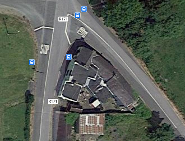 Google Maps View of Rte 171, Mullacrew, County Louth.
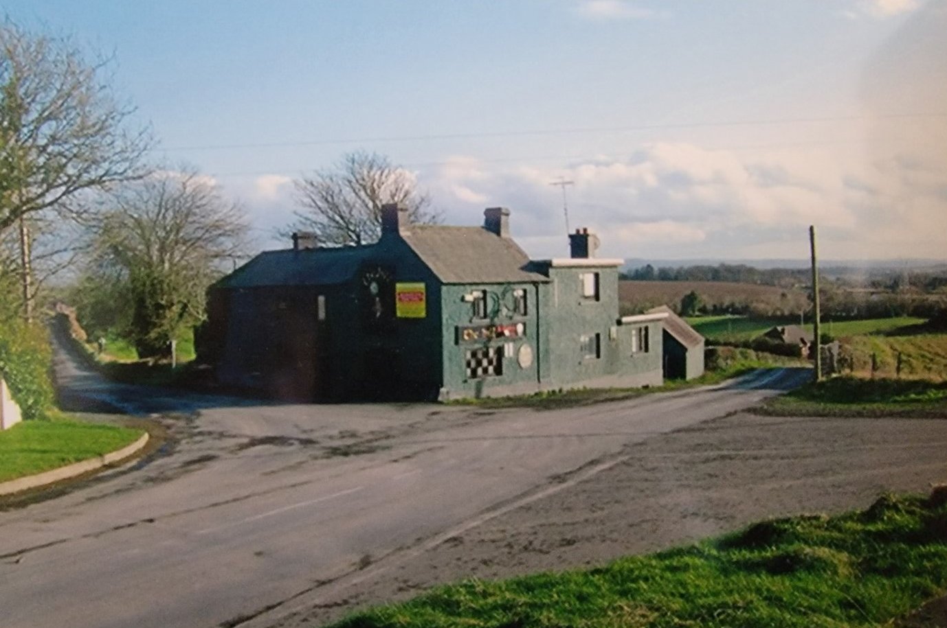
There was a large building standing next to a small home. As I zoomed in using Google Street View, I was able to spot the hanging Guinness sign over the door—it was indeed still a bar!
I found it interesting that the bar had two different signs—a large one proclaiming the name “The Hill,” likely due to its geographical placement, and another over the door that read “Sharkey’s.” The Sharkey family were neighbors to the Corcorans, my other County Louth ancestors, who lived in Dillonstown about twenty minutes south of Mullacrew.
Sadly, “The Hill” was put up for sale in the last few years and seems largely abandoned. I was fortunate to obtain a photograph from eBay of “The Hill” when it was operational (see below). I’m continuing to follow the timeline of the pub through Irish Newspaper Archives, which is available to search for members of American Ancestors. I have also contacted the County Louth archives to inquire about their publican licenses. I’ve even found stories about the pub on social media. It seems like it was once the center of activity of the town for Mullacrew. I’m happy to learn about this small piece of Irish history connected to my family.
Further Learning
Online Course: Using Irish Land Records in Your Family History Research
There’s still time to join this currently-running online course and get access to all lectures and course materials! We’ll delve deeply into ways that you can leverage Irish land records in your family history research. Register by March 27!
Free Research Guide: Irish Genealogy
Compiled by our expert genealogists, this research guide provides an overview of essential resources and strategies for locating your Irish ancestors.
Free Video: Understanding Land Divisions
Ireland has a unique and rather confusing system of land divisions which needs to be known and understood to effectively search for your ancestors. This lecture provides an overview of Irish land divisions and discusses their importance in family history research.
Notes
1 Ireland, Census, 1901, National Archives of Ireland, Mullacrew, County Louth, Ireland, House 15. Accessed on www.census.nationalarchives.ie.
2 Public Record Office of Northern Ireland (PRONI), Will Calendars, Bernard Duff, 1903, PRONI Will Calendars - Search.
3 Will Calendars, National Archives of Ireland, Patrick Duff, 1911, 005014917_00092 (nationalarchives.ie).
4 Griffith’s Valuation, Mullacrew, Louth, Louth, Louth, p. 39, Ask About Ireland, https://www.askaboutireland.ie/griffith-valuation/details.xml?action=showImage&mysession=2911145147312&ID=130003&rs=33
5 Ibid.
6 Griffith’s Valuation Map, Ask About Ireland, www.askaboutireland.ie