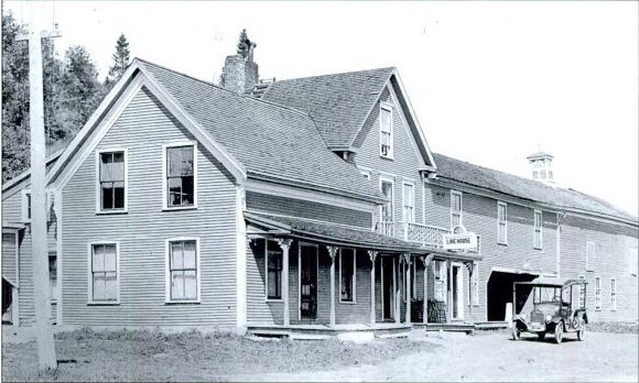
 Line house in Canaan, Vermont/Hereford, Quebec. Courtesy of Matthew Farfan, The Vermont-Quebec Border: Life on the Line.
As many genealogical researchers know, it is hardly unusual to have a person listed as born in one state on a census record, then ten years later, listed as having been born somewhere else. For instance, it is not unheard of to see a person listed as born in Virginia in 1910, West Virginia in 1920, and Kentucky in 1940. This is due largely to the fluid nature of state borders until relatively recently.
In the early days of the American settlement, large border disputes deriving from the use of multiple geographical surveys were fairly common. In May 1731, Connecticut formally transferred a strip of land known as ‘The Oblong’ to New York in exchange for the Connecticut panhandle, a border which still stands today.[1] Prior to 1731, the borders between New York, Connecticut, and Massachusetts were constantly changing, leaving landowners uncertain of the state where their land lay. Perhaps the most famous border settlement treaty, the Webster-Ashburton Treaty signed 9 August 1842, settled a long-standing debate over many areas along the border between the United States and Canada.[2]
Changes to state and international borders have resulted in one of the more interesting geographical anomalies, houses and buildings which fall within two different jurisdictions. According to the Philadelphia Inquirer, it is estimated that fifteen to twenty houses sit in both Pennsylvania and Delaware along the state borders.[3] These situations exist in nearly every state, sometimes as a result of unannounced, minor border changes. However, these changes can have a significant impact on property value, taxes, and laws.[4]
In 2013, surveyors in North Carolina used an original 19-foot-long map constructed in 1815 to retrace a 54 mile section of state boundaries through remote areas. During the original border construction in 1815, surveyors carved ‘NC’ and ‘SC’ into rocks and used them as markers for the state line.[5] Many of these rocks were located during the 2013 survey, covered in moss. Problems arose, however, when the 1815 maps used landmarks such as trees and fences which no longer exist. In these cases, state officials and historians utilized land grants and deeds that mentioned these landmarks as a way to determine the properties they bounded.[6]
Borders running through towns, villages, and even buildings are not a phenomenon restricted to the United States and Canada. The village of La Cure lies in both Switzerland and France, and at least four structures are divided by the international border, including the Hotel Arbez.[7]
While most of these cartographic oddities were the result of minor changes or incorrect measurements, sometimes the positioning of these sites was intentional. One such example is the Haskell Free Library and Opera House in both Derby Line, Vermont, and Rock Island, Quebec, Canada.[8] This national historic site (in both the United States and Canada), which opened on 7 June 1904, was deliberately built on the border between the two countries, as the donors who funded the building, Mrs. Martha Haskell and her son Col. Horace “Stewart” Haskell, wanted both Canadians and Americans to have access.[9] According to one account, “the laying of the cornerstone in 1901 was an international event with Masons from both sides of the line participating.”[10]
The Haskell Free library has two different entrances, one in America and one in Canada, and when exiting the library through the opposite entrance, patrons are then required to report to that country's customs. Because most of the library and the opera stage are located in Canada, the building is sometimes referred to as “The only library in America with no books” and “The only opera house in America with no stage.”[11]
Houses which have a state or national line running through them are known as ‘line houses.’ During Prohibition in the United States, line houses were constructed with a front door in America (most commonly in Vermont), while the rest of the building lay in Quebec, where alcohol could be served.[12] Additionally, the towns along the Canadian border came to play a significant role in the smuggling of alcohol across international borders.[13] Today, stricter state and international border patrolling has made such practices a thing of the past. Still, geographic shifts over the last 400 years have played a significant role in determining where a person called home.
Notes
[1] Phillip J. Schwartz, The Jarring Interests: New York's Boundary Makers, 1664-1776 (Albany, N.Y.: SUNY Press, 1979), p. 71.
[2] U.S. Department of State, Office of the Historian, Webster-Ashburton Treaty, 1842, https://history.state.gov/milestones/1830-1860/webster-treaty.
[3] Angela Palk, “Life in Two States – of Confusion: Their Homes Straddle Pa. and Del. That Means Double Bills, Taxes, Laws and Chaos,” Philadelphia Inquirer, 17 November 1994.
[4] Ibid.
[5] Nathaniel Axtell, “State line re-do has residents living in two states,” Times-News Online, 9 June 2013.
[6] Ibid.
[7] Hotel Arbez, http://www.arbezie.com/hotel-de-charme-les-rousses-jura-arbezie-vaud-pays-de-gex-geneve.html.
[8] Canada's Historic Places, Haskell Free Library, http://www.historicplaces.ca/en/rep-reg/place-lieu.aspx?id=7322&pid=0.
[9] Ibid.
[10] Cecile B. Hay, History of Derby (Littleton, N.H.: Courier Printing, 1967), p. 177.
[11] Haskell Free Library and Opera House, http://haskellopera.com/history/.
[12] Matthew Farfan, The Vermont-Quebec Border: Life on the Line (Mount Pleasant, S.C.: Arcadia Publishing, 2009), p. 115.
[13] Berkshire Historical Society, History of Berkshire (St. Albans, Vt.: L.G. Printing, 1994), p. 124.
