 A.F. Church, Yarmouth County Map: detail of Lake George in Nova Scotia
Tracing the origins of Canadian ancestors can be difficult, and the lack of early vital records can prove frustrating. Often, we have to turn to other sources to help piece together family histories. One of the “other sources” that I love to use are maps. Maps not only provide us with the locations of our ancestors’ homes or farms, they can also provide us with significant clues. Here are just a few sources that I have come across that I hope will aid you in your Canadian research.
Nova Scotia
Crown Land Grant Maps
The Crown Land Information Management Centre at the Nova Scotia Department of Natural Resources maintains Index Sheet Maps of Nova Scotia Crown Land Grant maps. If you know the general vicinity of where your ancestor settled, then the Index Sheet Maps will prove useful.
Here, you can click on each quadrant, and search for your ancestor’s name. I find maps like these useful because you can see who lived near your ancestor. Once you locate the land grant, you can email thensdnrlib@gov.ns.ca or call 902-424-8633 to order a copy of the corresponding documents.
William McKay's "The Great Map"
In 1834, William McKay completed the first comprehensive map of Nova Scotia. Some of these maps include the names of residents. These large scale maps are available at the Provincial Archives of Nova Scotia.
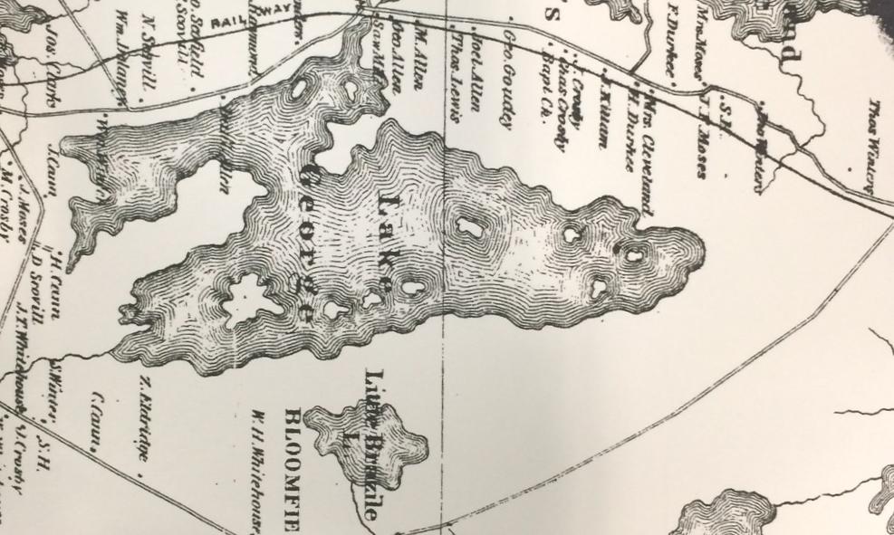
The A.F. Church maps
Cartographer Ambrose Finson Church created these detail-rich maps in the nineteenth century. Beginning with Halifax County in 1865, A.F. Church completed a map for each county until the completion of Queens County in 1888. These maps contain township information as well as heads of household, businesses, and prominent residents. I was able to locate some of my own ancestors near Lake George, just outside of Ohio in Yarmouth County. Here at NEHGS, we have these maps in our Technical Services Map Case.
Historical Maps of Nova Scotia
The Provincial Archives of Nova Scotia maintains a wonderful collection of maps. Many have been digitized, and you can search for them here.
New Brunswick
The Provincial Archives of New Brunswick has digitized and made available Cadastral Maps. On the Provincial Archives of New Brunswick website, these cumulative maps are organized by community within the Where is Home? section. These maps show the grantee of each Crown Land Grant.
Prince Edward Island
Another map that I really enjoy using is the 1863 Lake Map. Produced by civil engineer D. Jackson Lake, this map includes data from the 1861 Census of Canada, and you can view sections of this map by lot. Islandregister.com has digitized these maps, and we also have the 1863 Lake Map here at NEHGS. If you have Prince Edward Island ancestry, this map is a must!
